


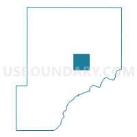
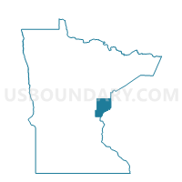
Danforth Twp. Voting District, Pine County, Minnesota
About
Outline

Summary
| Unique Area Identifier | 603626 |
| Name | Danforth Twp. Voting District |
| County | Pine County |
| State | Minnesota |
| Area (square miles) | 36.29 |
| Land Area (square miles) | 36.26 |
| Water Area (square miles) | 0.03 |
| % of Land Area | 99.92 |
| % of Water Area | 0.08 |
| Latitude of the Internal Point | 46.10450100 |
| Longtitude of the Internal Point | -92.59875520 |
Maps

Graphs
Select a template below for downloading or customizing gragh for Danforth Twp. Voting District, Pine County, Minnesota


Neighbors
Neighoring Voting District (by Name) Neighboring Voting District on the Map
- Arlone Twp. Voting District, Pine County, MN
- Clover Twp. Voting District, Pine County, MN
- Fleming Twp. Voting District, Pine County, MN
- New Dosey Twp. Voting District, Pine County, MN
- Ogema Twp. Voting District, Pine County, MN
- Partridge Twp. Voting District, Pine County, MN
- Sandstone Twp. Voting District, Pine County, MN
- Wilma Twp. Voting District, Pine County, MN
Top 10 Neighboring County Subdivision (by Population) Neighboring County Subdivision on the Map
- Sandstone township, Pine County, MN (824)
- Partridge township, Pine County, MN (639)
- Clover township, Pine County, MN (410)
- Arlone township, Pine County, MN (358)
- Ogema township, Pine County, MN (352)
- Fleming township, Pine County, MN (141)
- Danforth township, Pine County, MN (78)
- New Dosey township, Pine County, MN (74)
- Wilma township, Pine County, MN (65)